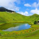
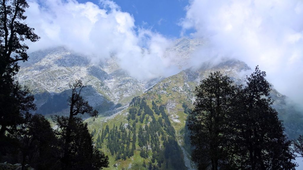
Starting with beautiful landscapes, sparkling streams in between the way, deep gorges sprouting from it all along to tranquil lakes and deodar forest down at the base till reaching atop; Indrahar Pass Trek In Himachal Pradesh is one of those outbursting pictures lingering traveler minds across age groups. Incredible blend of varied topography & associated vegetation one passes by while driving from 2875 m to 4425 meter high snow covered ground.
Indrahar Pass marks the boundary line between Kangra and Chamba districts presenting an extensive lay of Dhauladhar range on one hand side with thick sheet of snow or fascinating views from either side showing hamlets below. It also reveals the quiet waters of Lake Mankini and Kareri.
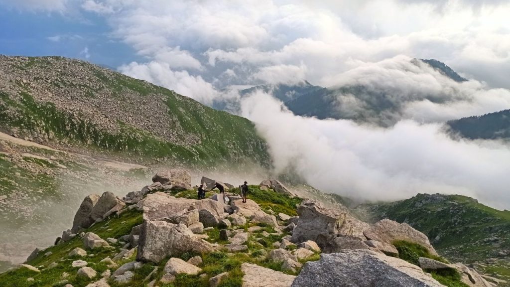
But still, as a matter of fact dark boulder road tracks even from the Dhauladhar along with Rhododendron and wide varieties of avifauna at different altitude not only simply enriches the journey but also have their own awe factor while traveling.
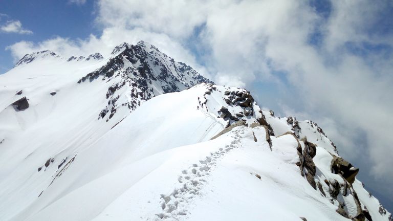
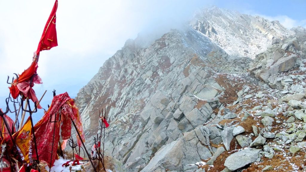
Then leaving the steep wall of Mon to its right, it makes a definite NW curve through open country and ascends unto the new face over rocks & vegetative matter coming off Lahesh Cave on another way up from Chatta Parao. The trail then crosses several ridges and ascents. The view from the pass is really beyond words.
In these wildflower-dusted alpines, one gets a 360-degree panorama – down south are the Kangra valley and faint blue vistas of Punjab plains while to your north rise cascading ranges like Pir Panjal in North- Kishtwar on West ; Bara Bangahal East and Manimahesh- North East.
- Geological Highlights of the Indrahar Pass Area
- About Indrahar Pass Trek
- Indrahar-Pass Trek Highlights
- Indrahar Pass Trek Overview
- Indrahar Pass Trek Difficulty Level
- How To Reach
- Tip For Travelers Before Going To Indrahar Pass
- Best Time To Visit
- Indrahar Pass Trek Route & Itinerary, Duration
- Things to do in Indrahar Pass Trek
- Distances
- FAQs
Geological Highlights of the Indrahar Pass Area
Indrahar Pass, is a mountain pass in the Himalayas range of mountains, India. The Indrahar-pass at an elevation of 4,342 meters or 14,245 ft is a mountain Pass in the Dhauladhar Ranges near Dharamshala and forms the border between Kangra district to Chamba District. One of the very popular treks passage from Dharamshala. This is a popular trekking circuit, it gets a lot of tourism from April – October.
About Indrahar Pass Trek
Location: Indrahar-Pass Trek starts from a height of 4425 m which is near Dharamshala in Kangra district as well it forms the border between Chamba District. The trek takes you through beautiful landscapes, gorges and streams as well as the lagoons in addition to extremely moist forest. Indrahar is Once in a lifetime experience and the best trek taken off numerous incredible treks of the loopThese are some beautiful landscapes that you will take back with yourself The ever so amazing Indrahar Pass Trek, Himachal Pradesh!
This trek began at McLeodganj and the distance of this great pass is 35 Km Long. And since it is near Dharamshala, this trekking destination in Himachal remains very popular. It is an amazing and mind-blowing trek that gives you a new experience of Trek.
Indrahar-Pass Trek Highlights
It starts in Dharamkot or Bhagsunag, and then through the Golu Devta temple. A stroll on this trek would soon lead to dense bush which in turn will be converted into a vast stretch of Oak and Rhododendron forests. The beautiful old Lahesh Caves : It is one of the key highlights on this trek.
This cave is located at an altitude of 3500 meters from sea level and can be reached only by trekking. You will be walking 4-5 hours a day during your stay so it is no trip for soft cocks. After exploring the caves, you can also take a leisurely walk in beautiful forests of oak, deodars, pine and fir trees. You will see the snow line as well while going towards Triund Mountains and BhagsuNag Temple.
Indrahar Pass Trek Overview

Located in the Himalayan range Dhauladhar, Indrahar-Pass Trek is one of the most popular trekking destinations which are located at a top altitude. Commencing at McLeodganj, the trail traverses lush forests, icy streams and vivid meadows to finally open out into the Indrahar Pass that gives you impeccable vistas of distant Himalayan peaks.
Indrahar Pass Trek Difficulty Level
MODERATE TO DIFFICULT : Indrahar-pass is a moderate-difficult trek starting from Dharamshala to Triund Snowline Cafe laka got and finally indrahar pass. The summit is approximately 14000 in height and takes between 4-5 days to reach the pinnacle.
How To Reach
1. By Rail:
- Nearest Railway Station: Amb Andaura
- Distance from McLeodGanj to Amb Andaura (Starting point for Indrahar-Pass): 65 kilometers
- Get a taxi from the railway station to reach McLeodGanj. Frequent public transport services can also be availed from Amb Andaura Railway Station to reach McLeodGanj.
2. By Road:
- Nearest Bus Station: McLeod Ganj
- McLeod Ganj is well connected to major cities by regular bus services. Your trek to Indrahar-Pass starts from McLeod Ganj itself.
3. By Air:
- Nearest airport : Kangra Airport at Dharamshala.
- After that you have to hire a taxi to reach Mcleodganj.
Tip For Travelers Before Going To Indrahar Pass
1. In case, you are travelers planning to visit this wonderful sight; so here we present some tips which could help when on your circulation at Indrahar Pass :
2. Before you go ahead for the trek, do keep up with a minimum fitness.
3. Windproof jacket, and already pack warm clothing (and gloves)
4. Buy trekking shoes (optional) & an extra pair of socks
5. Carrying sunscreen is a must.
6. Bring some shades and wear a hat or cap.
7. Do not forget the Camera!
8. Bring lots of water, snacks (including protein bars), and a backpack with good support.
Best Time To Visit
May to June, and then mid-September through the middle of October are the top periods you ought to visit this attractive place. Best time for you to visit : September-end to mid October months are ideal if you want cold vibes of Himachal just before actual snow starts.
If you also want to visit the land of beauty, snow-capped peaks and Oak forest with fresh breeze in peak summer months of May-June when scorching heat invites us all from Northern plains, please go ahead. Try not to visit here in monsoon. After October, the trail to Indrahar Pass is closed because of snowfall in the area.
Indrahar Pass Trek Route & Itinerary, Duration
Day 1: Mcleodganj-Leta Manu Adventures Camp
Mcleodganj to Leta Manu Adventures Camp via Upper Bhagsunag village. 2-3 hours walk.
(Mix of easy and uphill walk)
Day 2: Leta Village – Laka Glacier
Leta Village to Laka Glacier via Triund Duration: 4-5 hours trek
(Set-off early morning, after reaching Snowline it’s about an hour’s walk to Laka Glacier).
Day 3 : Laka Glacier – Indrahar pass
Laka Glacier – Indrahar pass via Lahesh caves. 5-6 hours walk.
(Difficult to steep climb).
Day 4: Laka Glacier – Triund
Laka Glacier to Triund back To Mcleodganj Walking Time: 4-5 hours
(Moderate to downhill walk)
Things to do in Indrahar Pass Trek
- Trek across the rocky terrain of Dhauladhar Range to reach Indrahar Pass, 14 km trekking provides you panoramic views of snow-capped mountains and green valleys.
- Indrahar Pass Trek is the gateway to heart-stirring vistas of the Kangra Valley and Pir Panjal Range, Indhraar pass is an epitome of many high mountain passes !
- Spot many Himalayan birds during the trek making your journey adventurous in added wildlife to rugged hills of The Great HIMALAYAS.
- Camping at Laka Glacier under the twinkling sky, beholding a canopy of stars and feeling tranquil in your tent amidst scenic majesty.
Distances
- Delhi to Indrahar Trek ; 405 kms
- Chandigarh to Indrahar Trek ; 178 kms
- Manali to Indrahar trek ; 75.9 kms
- Shimla to Indrahar Trek ; 152 kms
- Dharamshala to Indrahar trek ; 10.2 kms
- Kangra to Indrahar trek ; 23.9 kms
- Mcleodganj to Indrahar trek ; 8.3 kms
FAQs
Q.1. Is Indrahar Pass difficult?
Ans. The route from Ilaqa Pass to Indrahar Pass is steep and completely uphill. The difficulty level varies from moderate to strenuous. There is no vegetation and the terrain is mostly rocky.
Q.2. Where is Indrahar Pass?
Ans. Indrahar pass, perched at an elevation of 4342 meters (14,245 ft) above mean sea level on the crest line of the Dhauladhar Mountain range in Himalayas is situated at 32°17.852′N and 76°22. It’s a part of the very famous trek from Dharamshala.
Q.3. What is the Difficulty Level of the Indrahar Pass Trek?
Ans. Indrahar pass is moderate to difficult trek starting from Dharamshala-Triund-Snowline Cafe-laka gote- Indrahar pass. The summit is at a 14000 around height and takes approximately 4 -5 days to reach the zenith.
Q.4. How Long is The Indrahar Pass Trek ?
Ans. The Indrahar Pass trek started from McLeodganj and the trekking distance is 35 km. It is a popular trekking destination in Himachal because it is located close to Dharamshala.